2015 Street Tree Census ReportOne City | Five Boroughs | 666,134 Trees
TreesCount! 2015 Tree Data Variables
Census Overview
TreesCount! 2015 is the third citizen participatory inventory of street trees in New York City. Every ten years, NYC Parks has worked with volunteers to record the location, size, species, and condition of all public curbside trees. Volunteer street tree inventories promote increased awareness of the importance of the urban forest and support municipal urban forest management. New York City’s prior street tree inventories in 1995 and 2005 led to advances in customer service, funding for routine street tree pruning, the quantification of the ecological and economic benefits of trees, and a major urban greening campaign called MillionTreesNYC.
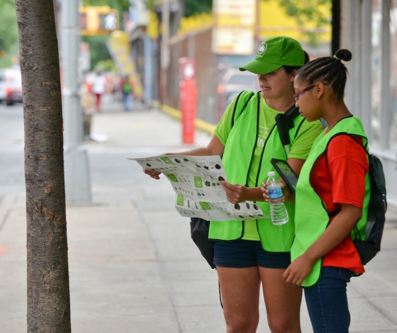
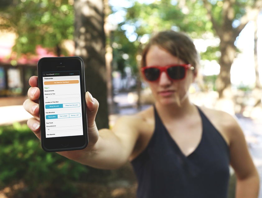
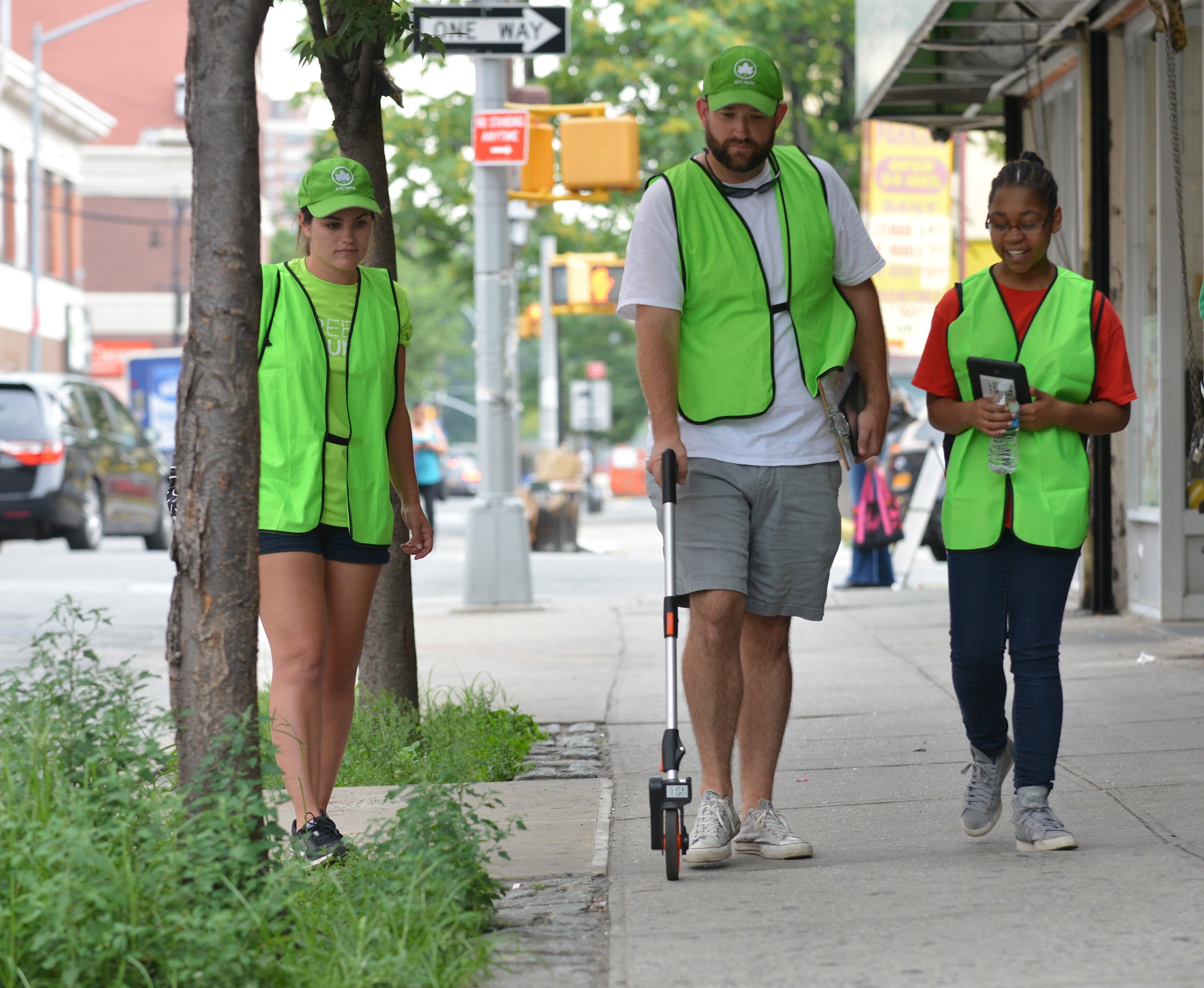
From May 2015 to October 2016, over 2,200 citizen mappers spent almost 12,000 hours using high tech mapping tools with survey wheels, tape measures, and tree identification keys to create a spatially accurate digital inventory of NYC’s street trees. The simple and intuitive mapping method was designed by a local non-profit, TreeKIT. The mapping technique leveraged a municipal geospatial dataset of curb edges to solve urban locational accuracy issues. The data collection method was integrated by the software company Azavea into a web application featuring online training modules, event management and community engagement tools to provide a seamless volunteer experience. The TreesCount! user experience was designed to scale for thousands of non-technical volunteers to collect standardized and consistent data with minimal training. To inspire public engagement, the web app featured real-time inventory metrics for individuals as well as partner community groups, and a progress map on the status of the data collection campaign. Powered by the public, TreesCount!2015 demonstrated that citizen science can support the collection of high quality spatial data for municipal urban forest management and ongoing citizen engagement.
Data collectors recorded eleven variables on each tree which included biological, structural, and infrastructural information. To learn more about each variable collected in the census, click here.
Results Summary
Volunteers
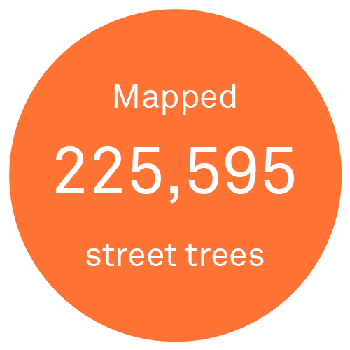
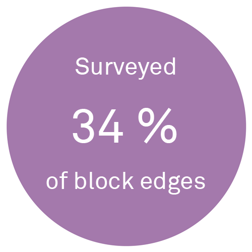
TreesCount! 2015 was the third decadal street tree census, and largest citizen science initiative in NYC Parks’ history. The 2015 census attracted 2,241 active volunteers, more than doubling involvement from the 2005 census; with the largest increases in participation seen in Brooklyn and the Bronx. The results of the census show that there are 666,134 trees planted along NYC’s streets, of which volunteers mapped and surveyed 225,595 (34%).
One of the recruitment strategies employed by NYC Parks in 2015 was to leverage existing relationships and build new ones with partner groups to reach individual volunteers. This strategy resulted in the involvement of 64 community groups who collectively mapped over 15% of block edges in the city. These groups ranged in size from large groups like the Prospect Park Alliance and the Lower East Side Ecology Center, to smaller groups like the Sunset Park Block Association and the Jackson Heights Beautification Project. The ten community groups with the most participants are noted in figure below:
NYC Parks also worked with US Forest Service social scientists at the NYC Urban Field station to survey volunteer census participants. Just over 27% of volunteers responded to the survey. The survey indicated that volunteers were students, retirees, tourists, taxi drivers, artists, and engineers, among many other backgrounds. For many respondents, volunteering provided them with a link to nature, taught them a new skill, or gave them a chance to explore their neighborhood and their city. Additionally, 59.6% of the volunteers that responded to the survey had never volunteered with NYC Parks before, and 46.9% had never worked with trees. We also learned from the survey that at least 11 participants in 2015 also volunteered in the first census in 1995.
NYC Parks also studied the quality of the data collected by different categories of census participants. The emphasis of the volunteer training was for participants to feel comfortable using their training and survey resources to make their best educated guess. Volunteers were also reminded that NYC Parks had a data quality process in place to identify spatial inaccuracies. In addition to volunteers, NYC Parks also hired and trained data collection staff in order to complete the census. To learn more about the data quality assurance process, and how volunteer-collected data compared to data collected by dedicated NYC Parks staff, check out this report.
Volunteer Map
Volunteer Training & Events
Volunteer Assessment Report
Click here to read more about volunteer training events, which took place throughout the course of the census.
Check out what motivated volunteers to count trees.
Did You Know?
The top five individual volunteers mapped a combined 35,995 trees, or 5.4% of all the street trees in NYC.
Volunteers walked 3,615 miles, equivalent to walking from New York City across the Atlantic Ocean to Madrid.
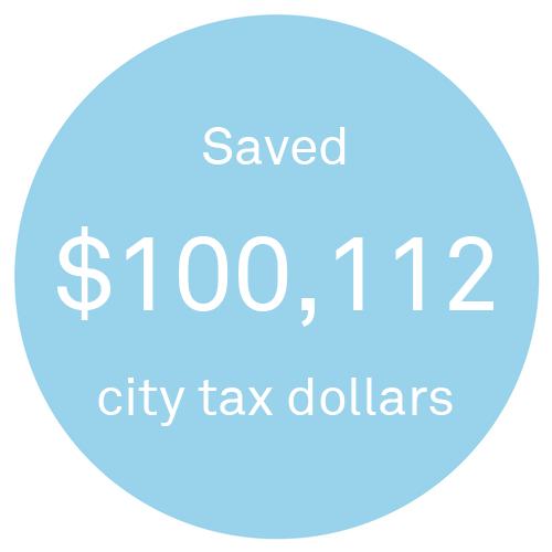
Volunteers donated approximately 11,123 hours to TreesCount! 2015, saving the city about $100,112 in tax dollars.
While more than two-thirds of volunteers resided in NYC, they also hailed from Long Island, Westchester and 15 different states across the U.S.
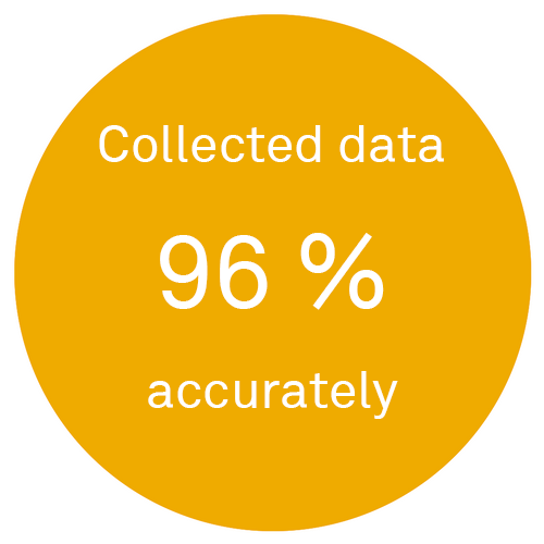
Volunteers mapped trees almost as accurately as dedicated Parks staff (96% accurate).
70% of volunteers who completed the volunteer survey said they felt more like a part of their neighborhood.
There were 12 volunteers who traveled to all five boroughs to map trees.
Williamsburg, Brooklyn was the one neighborhood in NYC that attracted volunteer mappers from all five boroughs. See this on a map!
NYC Parks acquired 890 survey wheels for the census.
Volunteer Testimonials
"My experience with TreesCount was amazing, I never thought about trees ever. Spending the last year documenting trees provided me with a new found appreciation of not only the trees but how they impact our everyday life. It has prompted me into further exploring other programs that address the impact of trees in an urban environment."
- Sunnyside, Queens
"We loved being part of the Tree Count. We learned lots about trees, visited interesting neighborhoods and had great conversations with residents. Made us feel more connected to our City."
- Prospect Heights, Brooklyn
"Treescount 2015 turned out to be one of the most engaging and rewarding volunteer activities I've had the pleasure to be a part of. I see the city in a whole new light now."
- Crown Heights, Brooklyn
"I now have a lot of time on my hands."
- Flatbush, Brooklyn
Technology
The 2015 Street Tree Census showcases technological advances across several dimensions, emblematic of a forward-thinking, transparent and community-oriented Parks department. The most notable differences from past efforts involved the baseline geospatial data, methods for mapping trees, and techniques for mobilizing volunteers and tracking progress. We also used technology to check the data for accuracy after it was collected. And the final deliverable of the census— the web map giving the data back to the public and updated daily for education, stewardship, and general awareness—is the enduring product of this high-tech vision for urban forestry in NYC. We also shared all of our datasets—from 1995, 2005 and 2015—with the public through the NYC OpenData portal so that anybody can analyze and learn about changes in the street tree population over time. Together, these technologies facilitated an enormous citizen science engagement project, a spatially precise street tree map, a living web application for public engagement in the urban forest, and a comprehensive dataset for anybody to download.
Treecorder Methodology
NYC Parks contracted with a software company, Azavea, to develop a responsive web application for digitized data collection and project collaboration. The code for this application is available as open-source software on GitHub. The elements of the web application, designed for use on (name types of devices), are as follows:
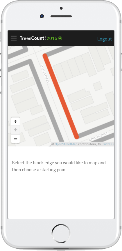
Data collection and mapping methodology. Over 90% of the census data was collected using a mobile device. The neighborhood-based participatory mapping and data collection methodology combined site surveying methods and geospatial technology to derive the location of street trees with a high degree of accuracy. The user-centric mapping method was designed by a local non-profit, TreeKIT, and integrated into a mobile-first web application created by Azavea. The mapping methodology itself solves several problems related to the accurate mapping of street features in urban environments where GPS doesn’t provide sufficient locational accuracy and is designed to scale for a wide variety and large number of non-technical users to collect standardized and consistent data with minimal training. The application, called TreeCorder, allows users to walk city blocks, recording the locations of trees and distances from the curb-line. Tree data was collected along blockedges, which were most often the strip of sidewalk between two intersections, on one side of the street. TreeKIT’s geometry constructor places each tree along each block face from the GIS base layer, at the distances the user specified in the TreeCorder.
Mobile Reservation System. In order to collect tree data, participants first had to reserve blockedges via the TreeCorder. The participant would sign in to the app and navigate to a map of all of the blockedges in the city. The map showed which blockedges were available for data collection, and which had already been collected. Users tapped each available blockedge they wanted to map, and the application added the blockedges to their queues. Once blockedges were reserved, they were shown as “unavailable” on the citywide map to prevent duplicate data collection. Community groups had a two tiered reservation system, by which swaths of blockedges were reserved for collection only by those associated with the group. In order for a participant to access these community group’s blockedges, the group leader had to grant access to the user to make reservations in that group’s zone. The majority of participants went through the two-tiered system, though independent mappers were able to reserve and map blockedges anywhere in the city.
Integrated collaboration platform. In addition to supporting the mapping methodology the TreesCount! Web application also supported community engagement and communication through online training, event registration and management, block edge reservation system, and live street tree count metrics and progress map. The platform supported individual volunteers as well as local organizations who committed to recruiting volunteers and hosting events to map specific sections of the City.
Vetting the volunteer-collected data. While the mapping methodology and web platform provided significant improvements to data quality compared to prior censuses, it was still possible for poor data to be collected either through data entry mistakes or a misunderstanding of the methodology. Our Quality Assurance (QA) process passed user submission through a series of automated checks focused on identifying potential errors. Some errors could be fixed in real-time, while others resulted in recollection. Analysis of QA data helped staff support volunteer engagement by refining the training curriculum and mitigating common sources of user error through focused refresher trainings and outreach. The collection methodology, user support, and QA review helped ensure the spatial accuracy of the NYC data.
Quality Assurance methods. Tree points were checked for a reasonable circumference measurement, positioning along sidewalks, and positions relative to the roadbed. Tree points were also spatially compared to aerial photos and Google Street View images. In many instances, errors in data collection were able to be fixed through a computer so that volunteers and/or Parks Expert Staff would not have to re-visit an area to collect the correct data. If any of the tree points along a given block face did not pass the QA checks and were not able to be manually fixed, the block face was marked as available for mapping. This gave Parks staff or volunteers a chance to recollect the correct tree data along that block face.
A live, interactive map of NYCs street trees. After collection and quality review, the tree inventory dataset was uploaded into NYCs urban forestry operational management system for daily use to support the tracking of all tree service requests, inspections, and work orders for work including pruning, removal, planting, and storm-response operations. This data also partially populates a public facing, interactive web app called the NYC Street Tree Map that helps people to learn about the trees in their neighborhood, record and share stewardship activities, and view the ecological benefits of the tree(s) in front of their home, in their neighborhood, and across the entire city. This map is automatically updated daily with inventory changes from Parks’ forestry management database. The NYC Street Tree Map is viewable at https://tree-map.nycgovparks.org
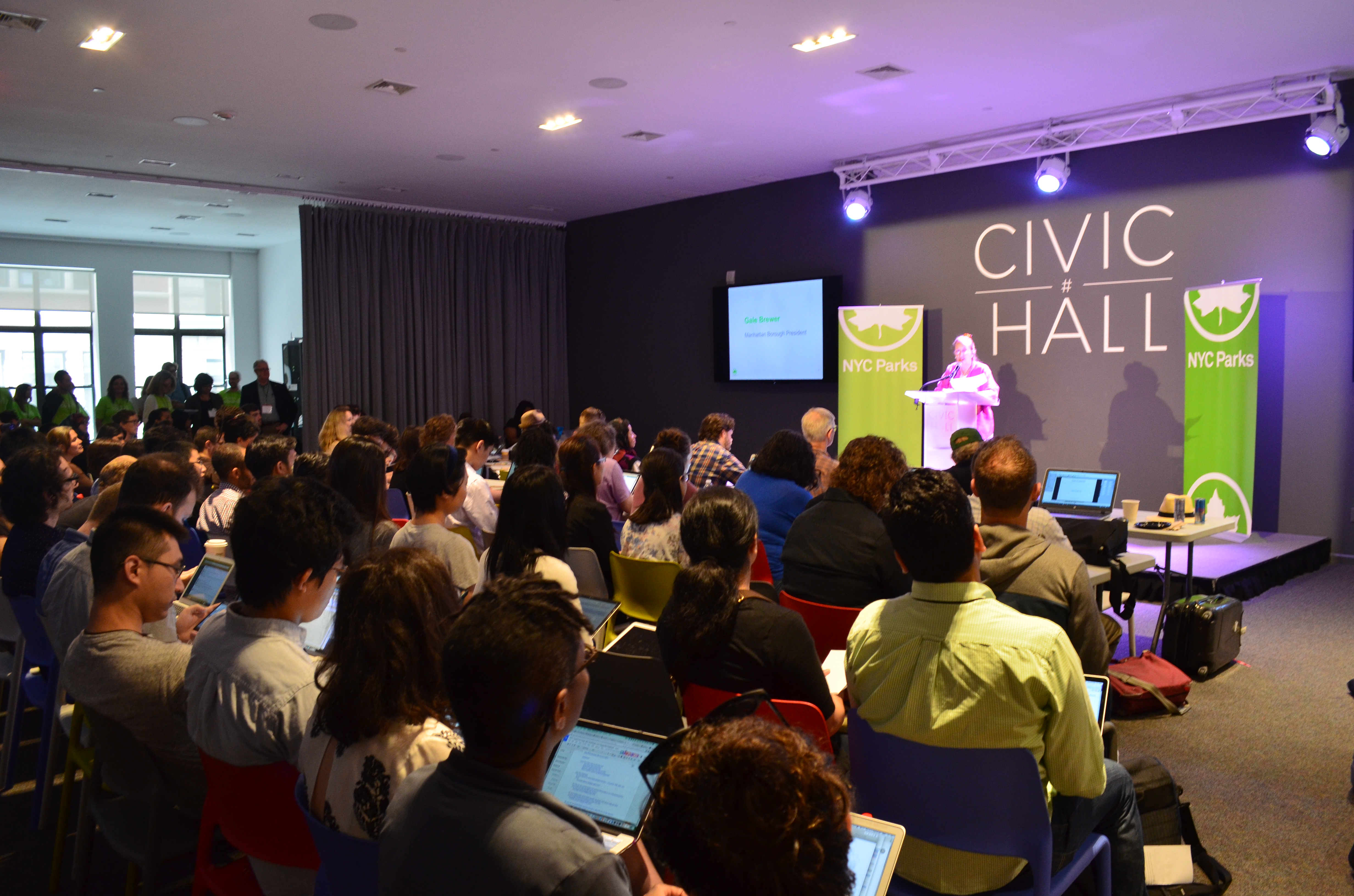
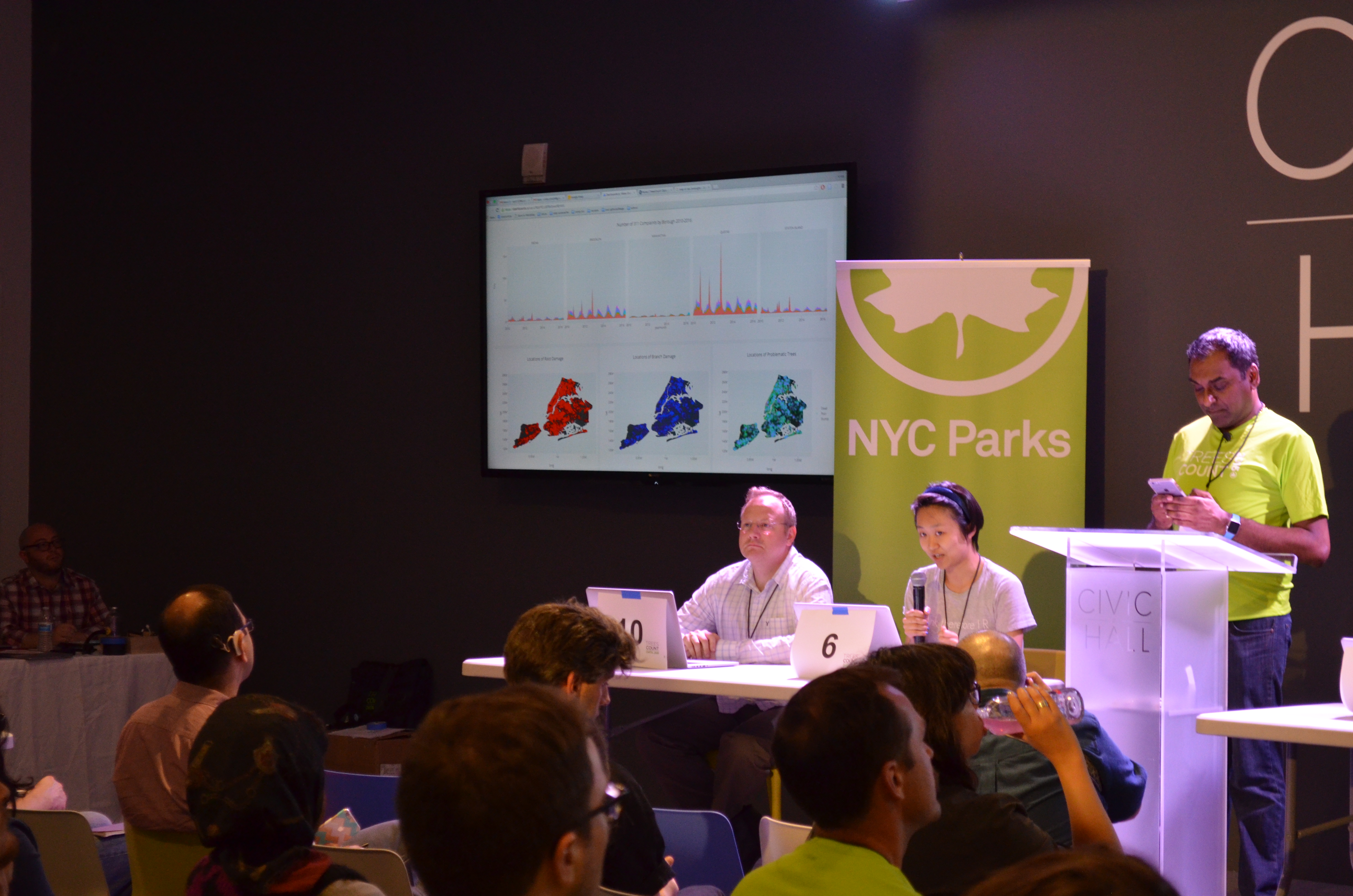
Open data in support of further urban forest insights. Parks is leading the way in terms of data sharing and transparency. Open Data has the potential to change the way citizens and community groups interact with and collaborate with government to effect change in their neighborhoods. In addition to posting the complete datasets from the 1995, 2005, and 2015 street tree counts on the OpenData portal, Parks hosted the TreesCount! Data Jam inviting civic technologists to help them maximize what NYC can learn from the data, and coaching tree census volunteers on how to analyze the data themselves, helping them become “digital tree stewards”. This Data Jam highlighted problem statements and questions framed as challenges for 144 workshop participants. In addition, 27 participants engaged in a six hour long session describing the open data portal and the nuances of mapping and data exploration.
The following (4) TreesCount! 2015 data products are on NYC's Open Data Portal:
Our hard-working street trees are in constant service to the people of New York City. They absorb gaseous air pollutants, provide cooling summer shade, and offer pastoral natural beauty amid the concrete jungle. By surveying street trees, we can collect baseline data on the state of a population in order to track changes in this population in the future.
The 2015 census counted 666,134 street trees citywide, a 12.5% increase from 2005. Queens has the most trees, with 242,414, followed by Brooklyn with 173,063 and Staten Island with 103,313 street trees. The borough with the greatest increase in population since 2005, however, is the Bronx (39%), followed by Manhattan (29%), and then Brooklyn (21%).
Select a borough below to view the number of trees in each community board, council district, or neighborhood.
Species Distribution
Census data collectors identified 132 different species of street trees citywide. London planetree, the most prevalent species in 1995 and 2005, was also the most common in 2015, with honeylocust and callery pear in second and third respectively. The most notable change in species composition since the last count is the drop in Norway maple from 14% of the population in 2005 to 5.2% in 2015. Other changes include the appearance of new species in the top ten, including Cherry, Japanese Zelkova, and Sophora*.
See these species on the NYC Street Tree Map! Click a
bar in the chart above and then click on the hyperlink. The
street tree map will be filtered to show the location of the
selected species across the city.
*Sophora is listed as Japanese Pagoda Tree on the NYC Street Tree Map.
This is another name for the species Styphnolobium japonicum.
NYC Parks' Street Tree Planting program has been paving the path for increased diversity of our urban forest since the beginning of PlaNYC and MillionTreesNYC. NYC Parks plants between 15,000-20,000 street trees annually, and take the time to think carefully about our species diversity goals. In 2016, the NYC Street Tree Planting Program planted just over 20,000 trees, comprised of 31 unique families, 61 unique genera, 190 unique species, and 362 unique cultivars. This attention to street tree diversity addresses NYC Parks’ mission of making NYC's urban forest resilient to pests, diseases, and other factors that could be more detrimental to forest health if monocultures are present.
Tree Health
Out of the 666,134 trees counted in New York City, 79.4% were rated in good condition, with the remaining trees judged to be in
fair condition (14.5%), poor (4.2%), or dead (2.1%). The Bronx has the highest percentage of trees in good condition (80.1%),
followed closely behind by Queens and Staten Island, where 80.0% of all trees in the boroughs were surveyed to be in good condition.
Select a borough below to view tree health by species and size.
Citywide Tree Health by Species*
Citywide Tree Health by Size
Size Class Distribution
Census data collectors measured the circumference of each street tree, which was then converted to diameter. The charts below show the sizes of trees in each census, in six inch groupings. These snapshots of the structure of the street tree population from 1995, 2005, and 2015 can also be compared for a better understanding of change over time.
Diameter Distribution: < 6 in. | 6-12 in. | 13-18 in. | 19-24 in. | 25-30 in. | 31+ in.
Citywide Size Class Distribution by Species
Select a species or genus below to view the street tree's size class distribution citywide.
*Showing the percent of total population for each species, for all trees surveyed between 2 and 40 inches in diameter.
Tree Benefits
Street trees provide multiple benefits that improve quality of life in New York City. Trees purify and cool the air, reduce stormwater runoff, and conserve energy. They increase property values, beautify neighborhoods, and improve human health and well-being. Although many of the benefits of trees are difficult to quantify, scientists with the U. S. Forest Service developed a model to measure the benefits of urban trees, called
I-Tree Streets. I-Tree Streets models tree growth by individual species and climate regions. When data on tree size and species is fed into the growth model, it yields an estimate of canopy size, leaf area and biomass for every tree. Benefits can then be calculated using local data including hourly climate and air pollution concentrations, energy costs, power plant fuel types and emissions, and building construction information. Each type of benefit is detailed below.
Showing benefit values for:
Stormwater Intercepted
916,464,980 gal/yr
Annual Benefit:
$36,658,598
Energy Conserved
49,867,160 kWh/yr
Annual Benefit:
$21,610,072
Air Pollutants Removed
543 tons/yr
Annual Benefit:
$2,352,110
Carbon Dioxide Reduced
118,764 tons/yr
Annual Benefit:
$4,322,986
Aesthetics
$130 per tree
Annual Benefit:
$86,371,642
Total Annual Benefits:
$151,315,411
Benefit-Cost Ratio:
3.03
Did You Know?
A large, healthy tree removes almost 70 times more air pollution each year than a small, newly planted tree1
The average electricity and natural gas cost savings in NYC are $32 per street tree
Each year NYC's street trees reduce summer electricity use from shading by 50,000 MWh
The average street tree in NYC intercepts 1,376 gallons of stormwater each year
NYC’s street trees capture 916 million gallons of water per year—the equivalent of over 3,500 Olympic-sized swimming pools
NYCs street trees sequester 57 thousand tons of carbon dioxide each year; this is the same as taking over 11,700 passenger
cars off the road
Stormwater Interception
Urban stormwater runoff is a major source of pollution entering wetlands, streams, lakes, and oceans.
Healthy trees can reduce the amount of runoff and pollutants in receiving waters. The interception benefit
is the amount of rainfall that does not reach the ground because it evaporates from the crown. As a result,
the volume of runoff is reduced and the time of peak flow is delayed. Trees protect water quality by
substantially reducing runoff during small rainfall events that are responsible for most pollutant washoff.
Energy Conservation
Trees save energy for heating and cooling by shading buildings, lowering summertime temperatures, and
reducing wind speeds. Secondary benefits from energy conservation are reduced water consumption and
reduced pollutant emissions by power plants.
Air Pollution Removal
Air pollution is a serious health threat to many city dwellers, causing asthma, coughing, headaches, respiratory
and heart disease, and cancer. Urban forests provide six main air quality benefits:
They absorb gaseous pollutants (e.g., ozone, nitrogen dioxide, and sulfur dioxide) through leaf surfaces.
They intercept dust, ash, pollen, smoke.
They release oxygen through photosynthesis.
They transpire water and shade surfaces, which lowers air temperatures, thereby reducing ozone levels.
They reduce energy use, which reduces emissions of pollutants from power plants, including nitrogen dioxide, sulfur dioxide,
and volatile organic compounds.
They reduce evaporative hydrocarbon emissions and ozone formation by shading paved surfaces and parked cars.
Carbon Dioxide Reduction and Storage
Global temperatures have increased since the late 19th century, with major warming periods from 1910 to 1945
and from 1976 to the present. Human activities, primarily fossil-fuel consumption, are adding greenhouse gases
to the atmosphere. Urban forests have been recognized as important storage sites for carbon dioxide, the
primary greenhouse gas. Urban forests can reduce atmospheric carbon dioxide in two ways:
Trees directly sequester carbon dioxide in their stems and leaves while they grow.
Trees near buildings can reduce the demand for heating and air conditioning, thereby reducing emissions
associated with power production.
Aesthetic Benefits
The aesthetic benefits capture the effect of trees on property values (in dollars).
The method the i-Tree Streets model uses to determine aesthetic value is based on a study by Anderson
and Cordell (1988), "Influence of trees on residential property values in Athens, GA: A survey based on
actual sales prices." This publication can be found here.
The median listing price for NYC single-family homes (from Zillow.com) was used as the "Average Resale
Home Value" in the i-Tree model.
1Nowak, D.J. 1994d. Air pollution removal by Chicago's urban forest. In: McPherson, E.G, D.J. Nowak and R.A. Rowntree. Chicago's Urban Forest Ecosystem: Results of the Chicago Urban
Forest Climate Project. USDA Forest Service General Technical Report NE-186. pp. 63-81.
New Tree Potential
Now that we’ve mapped all the street trees in New York City and can see exactly where trees are, we can also see where there are opportunities for additional planting. The New Tree Potential maps and charts estimate how many more spaces there are for street trees in neighborhoods across New York City. This new tree potential is the gap between current street tree levels (current stocking) and the maximum number of street trees possible (called full stocking). As of the 2015 census results, the streets of New York City are about 73.7% stocked, with space for an estimated 240,000 new street trees across the five boroughs. Areas targeted for new trees are shown below (dark blue colors indicate the most potential for new trees). Select a borough below to see the New Tree Potential across community boards, neighborhoods, and council districts.
 Return to NYC Parks website